English Teacher in Sudan
Khartoum 2008
I taught English as a second language in Khartoum during 2008. Sudan with its huge UN and other NGO presence is not really a popular holiday destination for anyone. I prefer working in these undiscovered developing countries where one can still find the real culture, unspoiled and un-trampled by tourists and tour buses. I explored Khartoum mostly by foot, sometimes in searing heat, taking pictures for which I got arrested once. The president at that time Mohammed Al Bashir was indicted by the World Court for crimes against humanity. At that time civil war still existed between the North and the South, the oil-rich South seeking independence from the Arab North. The bridges across the Nile into Khartoum proper were perfect insertion points for the Southern rebels.
I wanted to take pictures of the bridges, and other Khartoum street scenery, which was considered an act of espionage. Fortunately, after lots of prayers, I was released after my true identity was discovered. Hence taking pictures was quite a challenge for a snap-happy chappy like myself. To continue my obsession I had to devise plans not to be seen. Most of the pictures I took of bridges and other politically sensitive positions had to be done from the hip, like a gun-slinger.
 |
| Khartoum railway bridge - connects Khartoum proper and Bahri (Khartoum-North) |
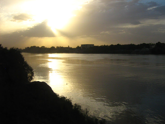 |
| Nile sunset - near Nile street, Buri |
About Sudan
Sudan (Arabic: السودان Al-Sudan) is the third largest country in Africa and sixteenth largest in the world, bordering Egypt, Eritrea, Central African Republic, Chad, Ethiopia, Libya, and South Sudan. Sudan is afflicted by civil wars which have been raging, on and off, for more than 40 years. When the colonial map-makers divided up Africa, they included in Sudan the predominantly Muslim people of the north (including Nubians), who share much of their history and culture with Egyptians and Arabs, and the largely Christian and Animist Nilotic and Bantu people of the south, who have more in common with the rest of sub-Saharan Africa than with their northern neighbours (Wikitravel).
Khartoum & The Nile
Khartoum means "elephant trunk" in Arabic. Khartoum (Arabic: Al-Khartum) is the political capital of Sudan. The Three Towns: Khartoum, Omdurman, and Khartoum North—together comprise the political, commercial, and administrative centre for Sudan. Located where the Blue Nile and White Nile join to flow north toward Egypt, the capital city is the largest urban complex in Sudan (encyclopedia.com). Khartoum is a metropolis with an estimated overall population of over five million people, consisting of Khartoum proper, and linked by bridges to Khartoum North called (al-Kharṭūm Baḥrī ) and Omdurman (Umm Durmān ) to the west (Wikipedia).
The Blue Nile flows between Khartoum and Bahri, the White Nile between Khartoum and Omdurman, and the merged Nile between Bahri and Omdurman. The confluence of the Blue and White Nile, known as Al-Mogran, which confluence at Tuti island, lies just north of the bridge between Khartoum and Omdurman (Wikitravel).
 |
Brickmaker on the banks of the Nile near my home on Nile street in Buri.
For exercise, I often ran along the banks of the Nile through agricultural land |
 |
| Sunset cruise on the Nile for tourists and more affluent Sudanese |
 |
| Agricultural Water pump on the banks of the Nile. Across the Nile, the ultra-rich living in villas of grandeur. |
Khartoum climate & agriculture
Khartoum is located in the semi-arid savanna belt of Sudan, with an average annual rainfall of 100-200 mm and a long dry season from September to June. A wide range of production systems can be found ranging from household subsistence to large-scale commercial farming. Crops grown in Khartoum state comprise a long list of vegetables, fruit trees, medicinal and aromatic plants, and field crops. In addition, intensive livestock production systems for milk, meat, and poultry are operational within and around Khartoum city. Khartoum state with its unique position at the confluence of the Blue and White Niles represents an ideal location for food production, which is fully oriented to satisfy urban demands (El Siddig et al)
 |
| Seasonal farmer and a vendor chatting on farmland adjacent to the Nile |
 |
| Nile irrigation |
 |
| Temporary housing for farm laborers working the land adjacent to the Nile. During the flood season they move elsewhere. |
 |
| Taking a Nile bath after a hard days work |
 |
| The land adjacent to the Nile during dry season. It floods every year, then the seasonal farmers make way for fishermen |
 |
| Previously farmed, now being fished |
 |
| Prior to the flooding |
 |
| Nile during the flood season, taken from the roof of my villa |
 |
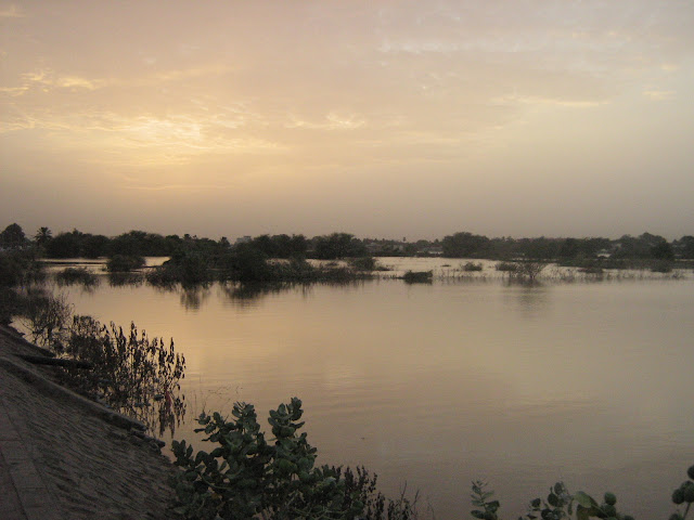
Nile farmland, with the 'Beverley hills' community across the Nile in the background -
This green area floods during rainy season. Farming is thus seasonal. |
 |
| Nile in flood at dusk |
 |
| The Nile during the flood season, coming right up the Nile street corniche |
Nile bridges
 |
| Sunset - Railway bridge |
 |
| Tuti bridge |
 |
| Man walking on Nile street corniche with the old railway bridge in the background |
 |
| Burri bridge |
Nile sunsets
 |
| Buri - Khartoum |
 |
| Buri - Khartoum |
 |
| Buri - Khartoum |
 |
| Buri - Khartoum |
 |
| Ferry terminal |
 |
| Ferry terminal |
 |
| The Nile |
The 'beach'
 |
| Khartoum 'beach' - Relaxing on the banks of the Nile |
 |
| The 'Beach', a popular swim spot and relaxation area next to the Nile- near Buri |
 |
| Fishing boat - Tuti island, where White and Blue Nile rivers confluence. |
 |
The scenery on Tuti island - Tuti bridge & Burj Al Fateh hotel across the river in Khartoum
|


No comments:
Post a Comment