English Teacher in Taiwan
10 - 21 May 2004
Whilst Teaching English as a Foreign Language in Taiwan, I took a 10-day break to travel to Thailand and Malaysia. Due to time limitations, I had to decide which places, in particular, I would like to see. I decided on Penang island, just off mainland Malaysia, Langkawi island, a 2-hour speed boat ride away, Phuket island, an island in Southern Thailand, and one night in Bangkok.
 |
| Fishing boat - Penang, Malaysia (2004) |
This trip took place during May 2004, about 6 months before the Tsunami destroyed much of the places I went to. I spent a couple of days on Penang island, exploring the island with my rented scooter and even drove a section of the 13.5 km Penang bridge that connects the mainland with Penang island. I then took a speed-boat ride to Langkawi where I spent about 3 days exploring the island, including taking a snorkeling trip to Pulau Payar. Later, I went to Phuket in Thailand where I spent about 4 days with two Swedish guys, I picked up hitch-hiking, and lastly on to Bangkok for a day before flying back to Taiwan.
Malaysia
About Penang
Penang is a Malaysian state and is located on the northwest coast of Peninsular Malaysia, by the Malacca Strait. It has two parts: Penang Island, where the capital city, George Town, is located, and Seberang Perai on the Malay Peninsula. It is known as the Silicon Valley of the East because of its industries. It is thus one of the most urbanized and economically-important states in Malaysia. Penang Island, which includes George Town, is Malaysia's second largest city by population. It was founded by the British in 1786. George Town is a UNESCO World Heritage Site and a thriving tourist destination (Wikipedia).
 |
I rented a scooter and explored Penang island -
driving through tropical green mountain rain forests |
 |
| Penang architecture |
 |
| Penang bridge that connects the mainland with Penang island |
 |
| Penang scenery |
About Langkawi & Langkawi Island
Langkawi is officially known as Langkawi the Jewel of Kedah. It is an archipelago of 104 islands in the Andaman Sea, some 30km off the mainland coast of Northwestern Malaysia. The islands are a part of the state of Kedah, which is adjacent to the Thai border. By far the largest of the islands is the eponymous Langkawi Island with a population of some 64,792. Langkawi is a duty-free island (Wikipedia).
 |
I rented this Malaysian-built car, a Proton, and drove down to bungalows,
right at a beach, where I slept in a hut with very basic amenities |
 |
| Beach volleyball - The hotel beach |
 |
| Langkawi |
 |
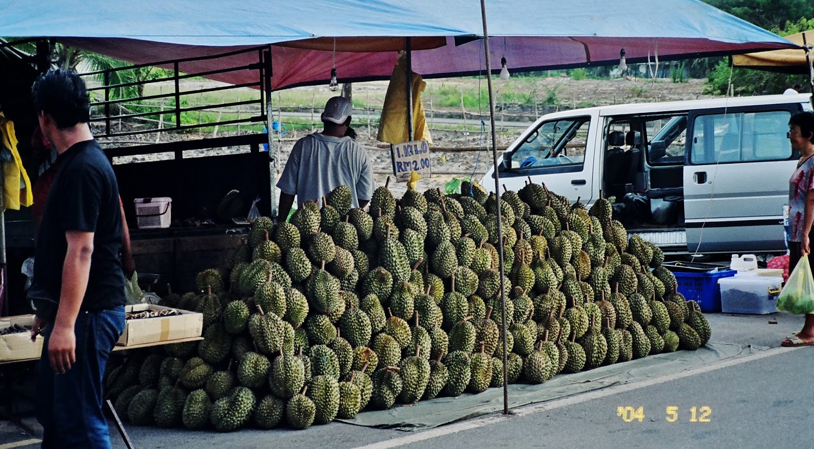
| Langkawi scenery - Fruit and veg market (This fruit pictured is called Stinky Durian fruit) |
 |
| Langkawi fishing boats |
 |
| Langkawi fishing boats |
 |
| Langkawi scenery: I came across these deserted bungalows next to a lake |
Snorkeling at Pulau Payar Island
Pulau Payar Island is one of the many islands off mainland Kedah in the Strait of Malacca, and is situated south of Langkawi, a more famous archipelago. Payar Island is a marine park that offers protection to a diverse marine life. It is a snorkeling and diving site famous for its corals. The Payar Island Marine Park is situated in the northern part of the Straits of Melaka, 35 km south of Langkawi. Payar Island, which measures about 2 km long and 1/4 km wide, is the most popular of the islands and is ideal are for snorkeling, diving, and swimming (Wikipedia).
I bought a disposable underwater camera in Langkawi, and was able to get some shots of fish whilst snorkeling at Pulau Payar.
 |
Departure from Langkawi on a Snorkeling Day-trip to Pulau Payar Marine Park -
posing with the guide |
 |
| On the boat en route to Pulau Payar |
 |
| On the boat en route to Pulau Payar |
 |
| On the boat en route to Pulau Payar |
 |
| Pulau Payar island |
 |
| Pulau Payar island |
 |
| Pulau Payar island |
 |
| Fish, taken with my underwater camera - Pulau Payar island |
Thailand
About Phuket
Phuket is one of the southern provinces of Thailand. It consists of the island of Phuket, the country's largest island, and another 32 smaller islands off its coast. It lies off the west coast of Thailand in the Andaman Sea. Phuket Island is connected by the Sarasin Bridge to Phang Nga Province to the north. Phuket Province has an area of 576 square kilometres, and is the second-smallest province of Thailand. It formerly derived its wealth from tin and rubber, and enjoys a rich and colourful history.
The island was on one of the major trading routes between India and China, and was frequently mentioned in foreign ship logs of Portuguese, French, Dutch, and English traders. The region now derives much of its income from tourism (Wikipedia).
 |
| Phuket |
 |
| Phuket |
I rented a Suzuki jeep to explore and saw 2 guys hitchhiking. It was a tall blonde guy, called Sven and a short dark guy. Sven introduced this short dark South American as his brother. Needless to say, I could see no resemblance until they explained, that Sven's family adopted his brother. We spent the next 3 days together exploring Phuket.
 |
| Sven posing at the Suzuki jeep I rented whilst in Phuket |
 |
| Phuket beach |
 |
| Phuket beach |
 |
| Posing with Sven's adopted brother at a Phuket beach |
 |
| Fishing boats - Phuket |
 |
| Fishing boats - Phuket |
 |
| Phuket market at a tourist spot |
 |
| Phuket fishing boats |
 |
| Tanning on the beach near our hotel |
 |
| Enjoying the hotel pool |
 |
| Our dinner |
 |
| Exploring Phuket - Lunch at a jetty with boats that take you on rides |
 |
| View of the deck restaurant |
 |
| View from where we sat |
 |
| View from where we sat |
 |
| View from where we sat |
About Bangkok
Bangkok is the capital and most populous city of Thailand, and is known in Thai as Nakhon Krung Thep. The city occupies 1,568.7 square kilometres in the Chao Phraya River delta in Central Thailand. It has a population of over 8 million, and 12.6 percent of the country's population. Over 14 million people (22.2 %) live within the surrounding Bangkok Metropolitan Region.
Bangkok traces its roots to a small trading post during the Ayutthaya Kingdom in the 15th century, which eventually grew and became the site of two capital cities: Thonburi in 1768 and Rattanakosin in 1782. Bangkok was at the heart of the modernization of Siam—later renamed Thailand—during the late 19th century, as the country faced pressures from the West (Wikipedia).
 |
| Famous tourist street in Bangkok |
 |
| In the back of a Tuk-Tuk in Bangkok traffic |
 |
| Bangkok |
 |
| Bangkok Housing |
 |
| Bangkok street scene near my youth hostel |